Mission of ASF with WWF Madagascar - Monitoring of Deforestation on 1,3 Million Hektars
Published on
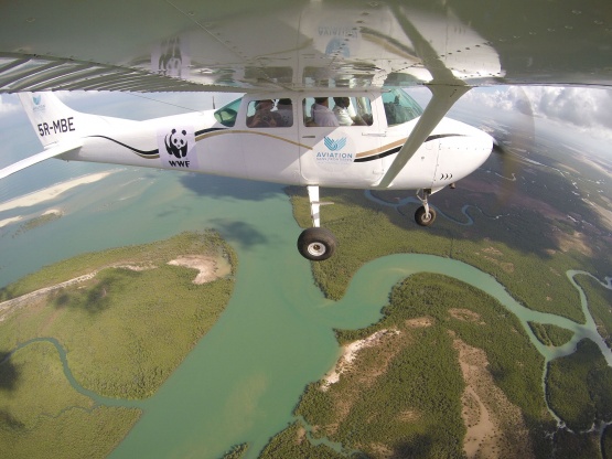
During November and December 2017Aviation sans Frontières and WWF Madagascar have been monitoring deforestation on 1,3 Million hectares of protected areas.
In tropical developing countries many protected areas are deforested by slash-and-burn agriculture, a practice difficult to accurately detect, even using satellite imagery.
In order to reduce deforestation and reduce by the way the risk of subsequent humanitarian crisis, ASF works since 2008 with WWF-Madagascar on aerial surveillance of protected areas.
The methodology of aerial surveillance with oblique photography was developed by ASF in partnership with WWF Madagascar, Madagascar National Parks and the « Système d’Aires Protégées de Madagascar ».
These are the main steps of this methodology
- Aerial surveillance : Protected areas are pictured annually from a light aircraft flying at a height of 500 m above the ground along fixed transects spaced 3 km apart.
- Monitoring of deforestation: Comparison of images between years reveals new clearings, which are accurately located and measured using Google Earth and other GIS software. This data allows for inter-annual monitoring of deforestation
- Orientation of patrols: Oblique aerial pictures and associated maps are used by foot patrols to locate clearings on the ground and enforce rules or illuminate discussions between protected area managers and shifting cultivators.
This methodology has several advantages as a monitoring and management tool
- Cost: oblique aerial pictures, that cost 0.015 € per hectare of forest, are 6.8 to 14.6 times less expensive than high-resolution satellite imagery required for the same level of precision.
- Simplicity and ease of use: simple and easy to use at every stage, facilitating its adoption by protected area management agencies in tropical developing countries.
- Real-time data: Observers can have the information necessary to support foot patrols available within 24 hours if required.
- Easy to interpret: Oblique aerial images provide a powerful tool for dialogue with resource users and other stakeholders for use in participatory management.
- Complementarity with satellite and drones imagery: whereas drone imagery is mostly appropriated to areas easily accessible of less than 5000 hectares, airplane oblique aerial imagery is more appropriated for remote areas of more than 5000 hectares. Oblique aerial pictures also represent a strong tool to improve vegetation classification thanks to satellite imagery.